


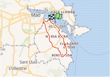
es castell sant esteve

Vinceneux
User

Length
10.8 km

Max alt
45 m

Uphill gradient
104 m
Km-Effort
12.2 km

Min alt
5 m

Downhill gradient
110 m
Boucle
Yes
Creation date :
2023-05-29 14:23:11.296
Updated on :
2023-05-29 16:44:57.92
2h20
Difficulty : Difficult

FREE GPS app for hiking
 SityTrail
IGN / Geographical institutes
SityTrail Plus
The world is yours!
About
Trail Walking of 10.8 km to be discovered at Balearic Islands, Unknown, es Castell. This trail is proposed by Vinceneux.
Positioning
Country:
Spain
Region :
Balearic Islands
Department/Province :
Unknown
Municipality :
es Castell
Location:
Unknown
Start:(Dec)
Start:(UTM)
610109 ; 4415491 (31S) N.
Comments